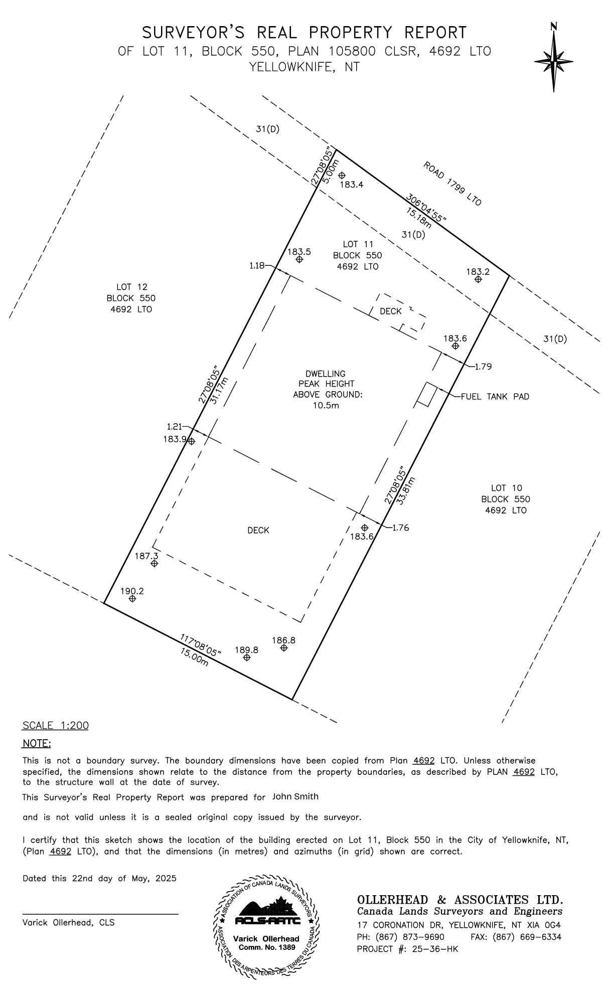
NORTH ARROW: Graphical symbol showing map orientation, indicating the north direction
TITLE: Identifies the type of survey, record, registration and property’s location
COMPANY CONTACT INFO: Clients can reach Ollerhead by phone, fax and email
NOTES: Identifies the sketch’s origin, registration, ownership, and validity
CERTIFICATION: Identifies the location, registration, azimuth, date, and surveyor’s seal
SURVEYED LOT: Registered land on which Real Property Report was conducted
ROAD: Public thoroughfare adjacent to the property, accessible by vehicles and pedestrians
SURROUNDING LOTS: Adjacent lots that are immediately next to the property
SURROUNDING LOTS: Adjacent lots that are immediately next to the property
PROPERTY BOUNDARY: Defines the legal limit of the surveyed area
DWELLING: Proposed house with peak height of 10.5m above ground
DECK: Elevated, flat, uncovered structure that is attached to the building
DECK: Elevated, flat, uncovered structure that is attached to the building
SCALE: Ruler of various ratio that measures distances from the drawing to real world
EASEMENT: The right to use the landowner’s property for various purposes
FUEL TANK PAD: concrete surface for home’s heating oil tank
SPOT ELEVATION: Measured level of a specific ground point on the lot
SPOT ELEVATION: Measured level of a specific ground point on the lot
SPOT ELEVATION: Measured level of a specific ground point on the lot
SPOT ELEVATION: Measured level of a specific ground point on the lot
SPOT ELEVATION: Measured level of a specific ground point on the lot
SPOT ELEVATION: Measured level of a specific ground point on the lot
SPOT ELEVATION: Measured level of a specific ground point on the lot
SPOT ELEVATION: Measured level of a specific ground point on the lot
SPOT ELEVATION: Measured level of a specific ground point on the lot
SPOT ELEVATION: Measured level of a specific ground point on the lot
DIMENSION: Measurement of the property line in meters
DIMENSION: Measurement of the property line in meters
DIMENSION: Measurement of the property line in meters
DIMENSION: Measurement of the property line in meters
BEARING: Measured direction of the property line
BEARING: Measured direction of the property line
BEARING: Measured direction of the property line
BEARING: Measured direction of the property line
BEARING: Measured direction of the property line along the easement
DIMENSION: Measurement between the property line and dwelling outline in meters
DIMENSION: Measurement between the property line and dwelling outline in meters
DIMENSION: Measurement between the property line and dwelling outline in meters
DIMENSION: Measurement between the property line and dwelling outline in meters
DIMENSION: Measurement of the property line along the easement in meters