STARTING WITH A DETAILED SITE PLAN IS THE BEST WAY TO COMMENCE ANY CONSTRUCTION PROJECT
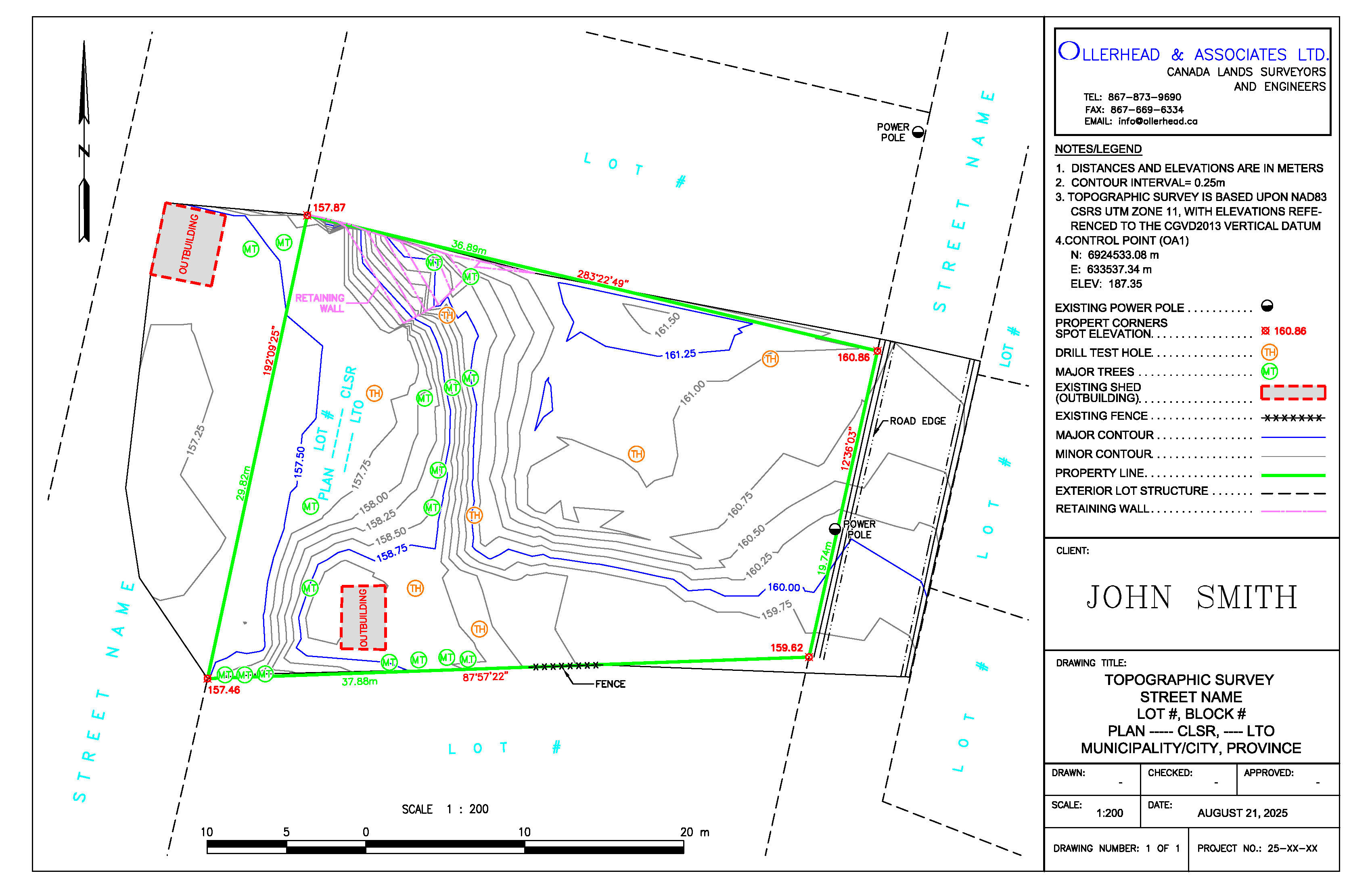
 A topographic survey provides a detailed map of the natural and man-made features of a site, including elevation data, contours, and physical structures. This plan supports various stages of construction and planning, such as obtaining development permits, designing new buildings, and creating stormwater management plans.
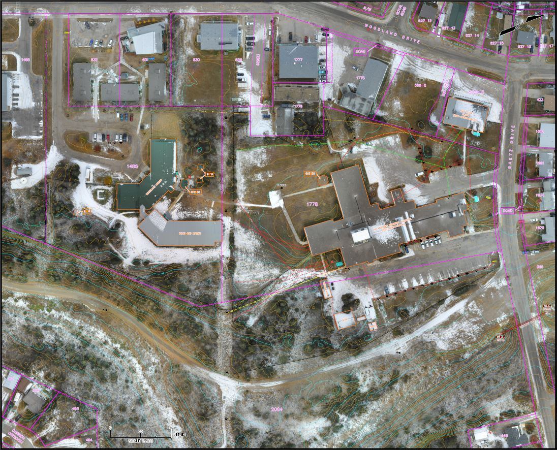
A topographic survey can be tailored to meet the specific needs of any project, from detailed 3D models to simpler plans showing boundaries and encumbrances only. Additionally, we offer the option to overlay high-resolution aerial imagery, captured with our Remotely Piloted Aircraft Systems (RPAS), onto the plan. This adds valuable visual context that can be essential for the successful execution of your project.
Why Choose Ollerhead & Associates?
With decades of experience serving communities across the Northwest Territories and Nunavut, we specialize in delivering customized surveys that are tailored to the unique requirements of your project. Our detailed and reliable data will support the successful design and approvals of your project.
COMPANY CONTACT INFO: Clients can reach Ollerhead by phone, fax and email

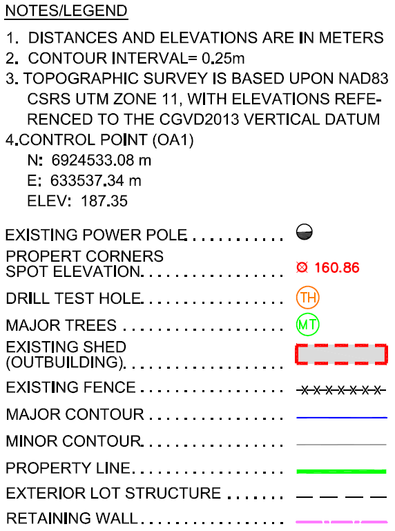
NOTES/LEGEND: Written explanations, references, and symbols to clarify the drawing
CLIENT: This section displays the company name or client’s logo

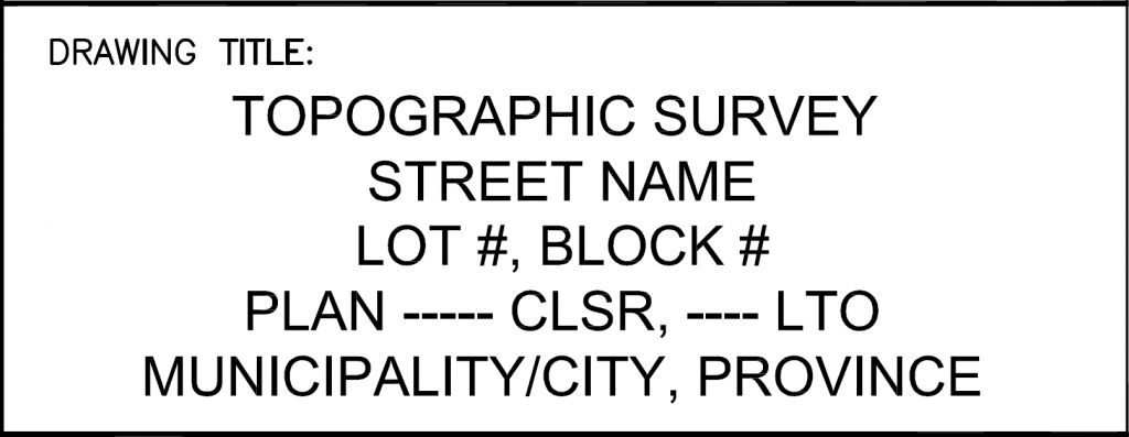
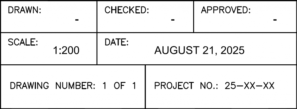
DRAWING TITLE: Contains survey types conducted, location, lot number, and plan number
This section includes information applicable to the drawing for clarity
NORTH ARROW: Graphical symbol showing map orientation, indicating the north direction
![]()
SURROUNDING LOT: Adjacent lots that are immediately next to the property

SURROUNDING LOT: Adjacent lots that are immediately next to the property
SURROUNDING LOT: Adjacent lots that are immediately next to the property
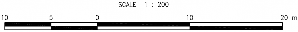
SCALE BAR: Graphic ruler that measures distances from drawing to real world
STREET: Public road adjacent to property, accessible by vehicles and pedestrians

STREET: Public road adjacent to property, accessible by vehicles and pedestrians
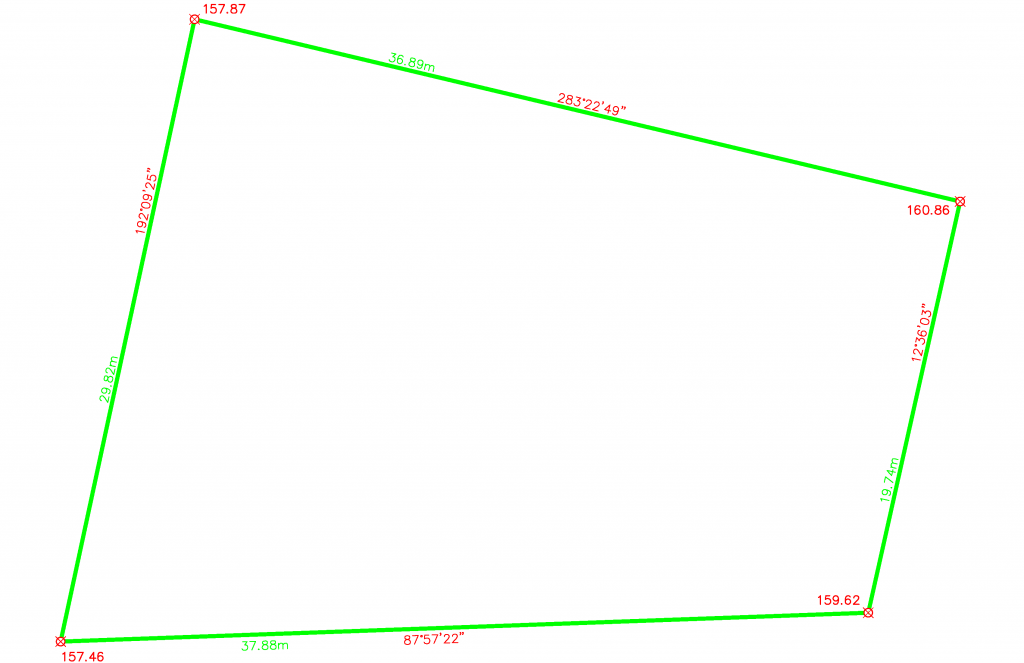
LOT AND PLAN NUMBERS: Identifies the land, record, registration of the property

TOPOGRAPHIC BOUNDARY SURVEY: Defines the outer limits of an area’s surface features
POWER POLE: Vertical structure supporting the overhead power lines and various utilities

POWER POLE: Vertical structure supporting the overhead power lines and various utilities
SPOT ELEVATION: Precise level of a point measured from the property corner

SPOT ELEVATION: Precise level of a point measured from the property corner
SPOT ELEVATION: Precise level of a point measured from the property corner
SPOT ELEVATION: Precise level of a point measured from the property corner
RETAINING WALL: Structure designed to restrain soil of the slope
FENCE: An outdoor vertical barrier defining property boundary

EXISTING SHED: Roofed and walled structure
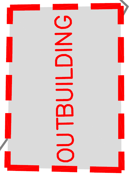
EXISTING SHED: Roofed and walled structure
DIMENSION: The length/measurement of the property line
DIMENSION: The length/measurement of the property line
DIMENSION: The length/measurement of the property line
DIMENSION: The length/measurement of the property line
BEARING: Describes the direction of the measured property line
BEARING: Describes the direction of the measured property line
BEARING: Describes the direction of the measured property line
BEARING: Describes the direction of the measured property line
ROAD EDGE: Indicating slope beyond this line
MAJOR CONTOUR: Shows major ground elevation changes every 1.25m
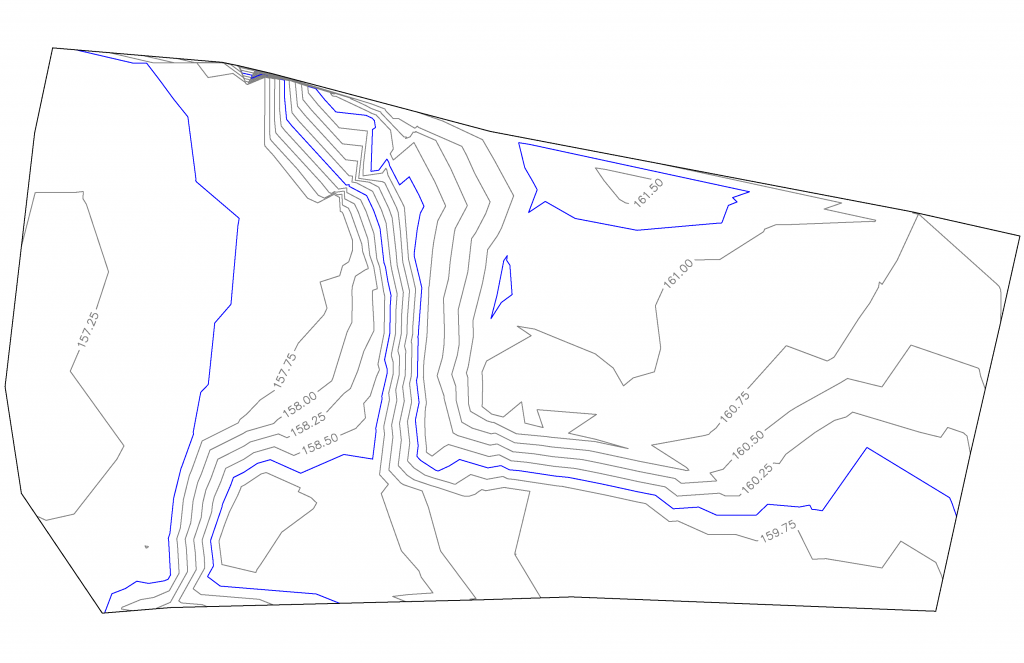
MAJOR CONTOUR: Shows major ground elevation changes every 1.25m
MAJOR CONTOUR: Shows major ground elevation changes every 1.25m
MAJOR CONTOUR: Shows major ground elevation changes every 1.25m
MAJOR CONTOUR: Shows major ground elevation changes every 1.25m
MINOR CONTOUR: Shows minor ground elevation changes every 0.25m
MINOR CONTOUR: Shows minor ground elevation changes every 0.25m
MINOR CONTOUR: Shows minor ground elevation changes every 0.25m
MINOR CONTOUR: Shows minor ground elevation changes every 0.25m
MINOR CONTOUR: Shows minor ground elevation changes every 0.25m
MINOR CONTOUR: Shows minor ground elevation changes every 0.25m
MINOR CONTOUR: Shows minor ground elevation changes every 0.25m
MINOR CONTOUR: Shows minor ground elevation changes every 0.25m
MINOR CONTOUR: Shows minor ground elevation changes every 0.25m
MINOR CONTOUR: Shows minor ground elevation changes every 0.25m
MINOR CONTOUR: Shows minor ground elevation changes every 0.25m
MINOR CONTOUR: Shows minor ground elevation changes every 0.25m
MINOR CONTOUR: Shows minor ground elevation changes every 0.25m
MINOR CONTOUR: Shows minor ground elevation changes every 0.25m
MINOR CONTOUR: Shows minor ground elevation changes every 0.25m
MINOR CONTOUR: Shows minor ground elevation changes every 0.25m
MAJOR TREES: Remarkable rooted tall plant with trunk, branches and leaves
MAJOR TREES: Remarkable rooted tall plant with trunk, branches and leaves
MAJOR TREES: Remarkable rooted tall plant with trunk, branches and leaves
MAJOR TREES: Remarkable rooted tall plant with trunk, branches and leaves

MAJOR TREES: Remarkable rooted tall plant with trunk, branches and leaves
MAJOR TREES: Remarkable rooted tall plant with trunk, branches and leaves
MAJOR TREES: Remarkable rooted tall plant with trunk, branches and leaves
MAJOR TREES: Remarkable rooted tall plant with trunk, branches and leaves
MAJOR TREES: Remarkable rooted tall plant with trunk, branches and leaves
MAJOR TREES: Remarkable rooted tall plant with trunk, branches and leaves
MAJOR TREES: Remarkable rooted tall plant with trunk, branches and leaves
MAJOR TREES: Remarkable rooted tall plant with trunk, branches and leaves
MAJOR TREES: Remarkable rooted tall plant with trunk, branches and leaves
MAJOR TREES: Remarkable rooted tall plant with trunk, branches and leaves
MAJOR TREES: Remarkable rooted tall plant with trunk, branches and leaves
MAJOR TREES: Remarkable rooted tall plant with trunk, branches and leaves
MAJOR TREES: Remarkable rooted tall plant with trunk, branches and leaves
MAJOR TREES: Remarkable rooted tall plant with trunk, branches and leaves
DRILL TEST HOLE: Subsurface analysis for foundation, exploration, etc.

DRILL TEST HOLE: Subsurface analysis for foundation, exploration, etc.
DRILL TEST HOLE: Subsurface analysis for foundation, exploration, etc.
DRILL TEST HOLE: Subsurface analysis for foundation, exploration, etc.
DRILL TEST HOLE: Subsurface analysis for foundation, exploration, etc.
DRILL TEST HOLE: Subsurface analysis for foundation, exploration, etc.
DRILL TEST HOLE: Subsurface analysis for foundation, exploration, etc.